Ring Road Trip

The Icelandic Ring Road is considered  one of the best ring road trips in the world. I had been planning on going for a trip around Iceland for a few years and last week my dream finally came true.
7 days of driving (10, as advised in the article, seem too many for this trip) around the country was truly an amazing experience: I could admire beautiful landscapes such as geysers, glaciers, volcanoes, lava fields, waterfalls, cliffs and get to know the real Iceland with its cute small towns and villages. It’s impossible to describe the whole trip and share my pictures in one post, so I’m going to write several posts about my ring road experience. This one is a generic one, I hope that after reading it you’ll understand why I was so excited about this trip.

Islandzka Droga Numer 1 wiodąca dookoła kraju jest uważana za jedną z najlepszych tras na wyprawę samochodem. Planowałam tę podróż od dobrych kilku lat, a w zeszłym tygodniu udało mi się wreszcie spełnić to marzenie.
7 dni jazdy (10, jak w cytowanym artykule, to moim zdaniem trochę za dużo) dookoła Islandii były wspaniałym przeżyciem: mogłam podziwiać gejzery, lodowce, wulkany, pola lawy, wodospady, klify oraz poznać prawdziwą Islandię i jej małe, urocze miasteczka. Nie sposób opisać całą wyprawę i zamieścić zdjęcia w jednym wpisie, dlatego niebawem napiszę bardziej szczegółowe artykuły, ten natomiast jest ogólnym i dość pobieżnym postem o całej podróży. Mam nadzieję, że uda mi się w nim podzielić wrażeniami i pokazać, że warto udać się w wyprawę dookoła tego pięknego kraju.

0x

Navigating is very easy (there’s basically only one big road in Iceland), but it’s good to plan the trip in order to see all the nice spots without rushing too much.

Trudno się zgubić jadąc dookoła Islandii, bo Ring Road 1 jest jedyną większą drogą. Warto jednak dobrze zaplanować podróż, by móc zobaczyć główne atrakcje nie spiesząc się za bardzo.

Day 1/Dzień Pierwszy

Golden Circle (Þingvellir, geysers, Gullfoss) and relax in the swimming pool in Selfoss (more active people could do the Hot River Hike instead 🙂 )

Golden Circle, czyli Þingvellir, gejzery i Gullfoss oraz relaks na basenie w miejscowości Selfoss (tu alternatywą dla aktywnych może być szlak do gorącej rzeki w Hveragerdi.

01

01a

Day 2/ Dzień Drugi

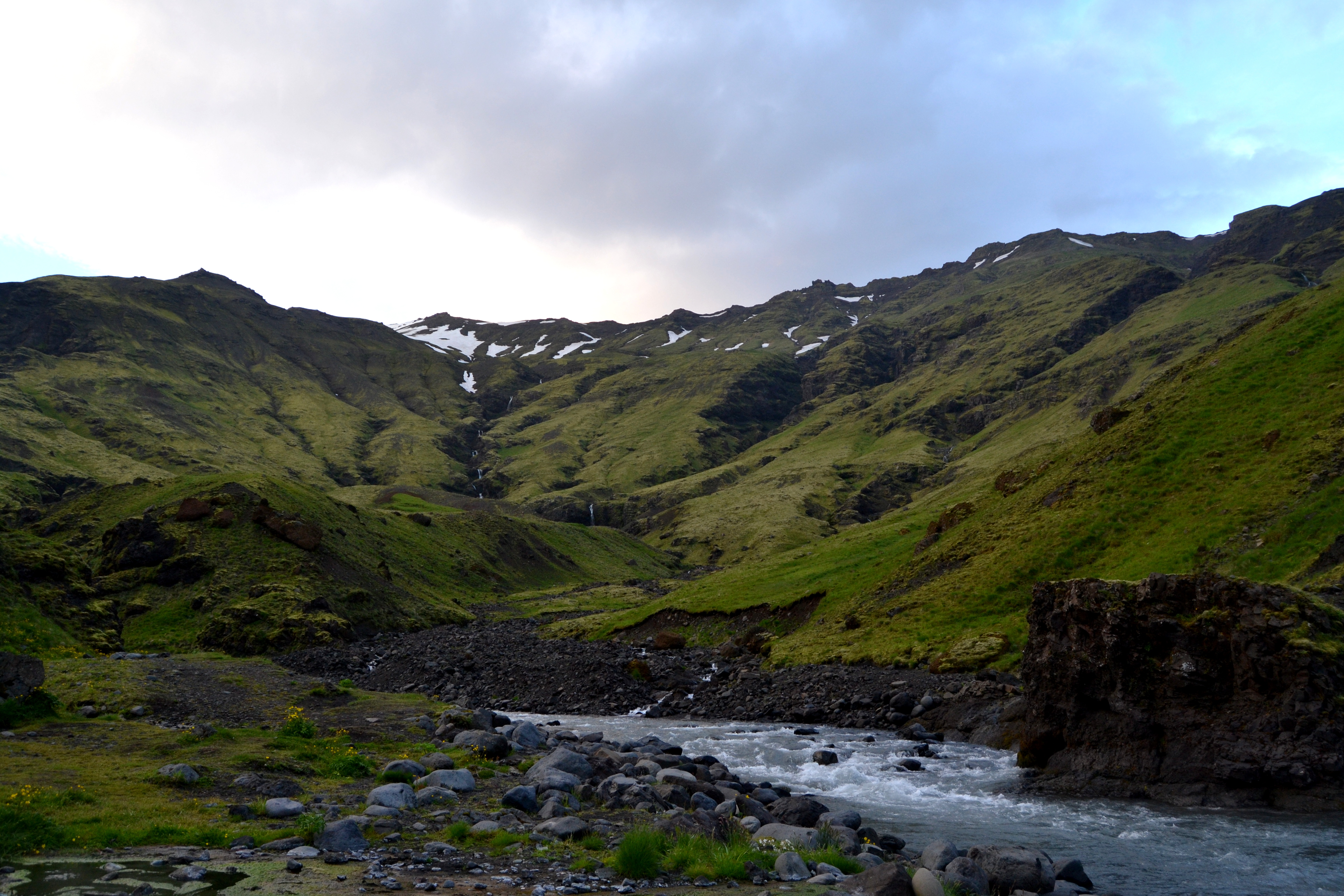
South Shore: waterfalls Seljalandsfoss and Skógarfoss, Eyjafjallajökull, Seljavallalaug pool, Sólheimajökull glacier, Vik and then driving towards the Skaftafell park by the beautiful lava fields.

Jazda wzdłuż południowego wybrzeża: wodospady Seljalandsfoss i Skógarfos, Eyjafjallajökull, basen Seljavallalaug, lodowiec Sólheimajökull, Vik, a stamtąd udaliśmy się do parku Skaftafell jadąc przez piękne pola lawy.

02

03

04

05

06

Day 3/Dzień Trzeci

Hike in Skaftafell, glaciers, Jökulsárlón and fjords in the East.

Górski spacer w Skaftafell, lodowce, Jökulsárlón i wschodnie fiordy.

07

08

Can you spot a seal in this picture? 🙂

09

Day 4/Dzień Czwarty

Beautiful waterfalls of the North and Krafla.

Spektakularne wodospady Północy oraz Krafla.

10

11

12

13

Day 5/Dzień Piąty

Geothermal areas Krafla and Hverarönd, the Myvatn lake and Akureyri.

Tereny geotermalne Krafla i Hverarönd, jezioro Myvatn i Akureyri.

15

16

17

Day 6/Dzień Szósty

Glaumbær, waterfalls Hraunfossar and Barnafossar.

Glaumbær oraz wodospady Hraunfossar i Barnafossar.

19

18

Day 7/Dzień Siódmy

Hvalfjörður and driving back to Reykjavik

Hvalfjörður i jazda z powrotem do Reykjaviku.

20

Two weeks in the South Shore

And another workcamp is over. This time I volunteered in the south of Iceland together with people from Slovakia, Italy and France. Our workcamp was in a beautiful area surrounded by mountains and glaciers to the north and facing the Atlantic Ocean to the south. We were just 10 minutes away from Dyrhólaey, a small peninsula and cliff and one of the most beautiful places in this part of Iceland. The view from up there is breathtaking: the Mýrdalsjökull glacier to the North and the famous black sand beach to the East.

******

I kolejny workcamp już za mną. Miał on miejsce na południu Islandii, gdzie pracowałam razem z wolontariuszami ze Słowacji, Włoch i Francji. Miejsce workcampu było naprawdę piękne: otoczone jest ono górami i lodowcami ze strony północnej i oceanem ze strony południowej.

Byliśmy zaledwie 10 minut od Dyrhólaey, małego półwyspu i klifu oraz jednego z najbardziej malowniczych miejsc w tej części Islandii. Widok stamtąd jest niesamowity: lodowiec Mýrdalsjökull na północy oraz słynna plaża z czarnym piaskiem na wschodzie. 01 02 I also went to the black sand beach. The weather wasn’t great, but the place was amazing. Pojechałam też na plażę. Choć pogoda nie była najpiękniejsza, to miejsce wciąż wyglądało wspaniale. 03 04 My favourite place in the south of Iceland is probably Seljavallalaug, a natural swimming pool nestled in one of the most picturesque valleys of the country. This is also one of the oldest swimming pools in Iceland. It is heated from hot spring water that trickles from Eyjafjallajökull.

*****

Prawdopodobnie moim ulubionym miejscem na południu Islandii jest Seljavallalaug, naturalny basen w jednej z najbardziej urokliwych górskich dolin tego kraju. Jest to także jeden z najstarszych basenów na Islandii. Jest ogrzewany przez wodę z gorących źródeł Eyjafjallajökull. 06 07 08 05 Another interesting attraction in the south of Iceland is the wreckage of a crashed U.S. Navy aircraft abandoned on a beach 40 years ago. In 1973 an airplane was forced to land on Sólheimasandur’s black sand beach in the south of Iceland after experiencing severe icing. Luckily all crew members survived the crash, but the airplane’s fuselage was abandoned and now lies hollow and forgotten on a deserted black beach – untouched since it crashed. Kolejną ciekawą atrakcją w tej części Islandii jest wrak amerykańskiego samolotu pozostawiony na czarnej plaży Sólheimasandur czterdzieści lat temu. W 1973 r. samolot musiał awaryjnie lądować z powodu oblodzenia. Wszyscy członkowie załogi oraz pasażerowe przeżyli lądowanie, a kadłub samolotu pozostał na miejscu i do dziś leży nietknięty na odległej plaży. 09 10 11 12 13 And some pictures from the Petursey hike – I lived literally two minutes from this mountain!

Poniżej kilka zdjęć ze wspinaczki na górę Petursey – mieszkałam dosłownie u jej podnóży. 14 15 16

Vestmannaeyjar

Since I arrived to Iceland I have heard so much about the archipelago of Vestmannaeyjar that I really wanted to go there. And on Saturday I finally did.

Vestmannaeyjar, often anglicized as Westmen Islands, is a beautiful archipelago off the south coast of Iceland. The islands have been formed by eruptions of numerous volcanoes in the area. The volcanoes are still active: Vestmannaeyjar came to international attention fourty years ago with the eruption of Eldfell volcano that lasted for 155 days. The eruption destroyed many buildings and forced a months-long evacuation of the entire population to mainland Iceland. Now celebrating the end of eruption has become a fixed event in the Vestmannaeyjar social life, it takes place every year on the weekend following 3rd of July, the day in 1973 when the eruption was officially declared at an end.

Moreover, the archipelago is famous because it was home to Keiko the killer whale, star of “Free Willy”.

The once difficult to reach archipelago is now easily accessible via ferry from Landeyjarhofn or via small plane from an airport located close to the port.

The archipelago consists of 15 islands, and about 30 rock stacks and skerries. The only inhabited island is Heimaey (which means in Icelandic “Home Island”) and that’s where I went. Heimaey is a small island (13.4 square kilometres) so one day is more than enough to see the main attractions there. I drove around the island, climbed the volcano and walked on large lava fields. I also admired beautiful landscapes: from Heimaey you can see other islands and the glacier in the Icelandic mainland.

It was an intense and tiring day so afterwards I headed to Sejlavallalaug – a beautiful natural swimming pool located between the mountains (I’ll write a bit more about it and post some pictures in next post).

Odkąd przyjechałam na Islandię usłyszałam tak wiele o wyspach Vestmannaeyjar, że koniecznie chciałam się tam udać. Udało mi się wreszcie to zrobić w zeszłą sobotę.

Vestmannaeyjar, po angielsku Westmen Islands, to piękny archipelag nieopodal południowego brzegu Islandii. Wyspy te powstały w wyniku erupcji licznych wulkanów, które znajdują się w tym rejonie. Są one wciąż aktywne: o wyspach Vestmannaeyjar głośno było czterdzieści lat temu za sprawą 155-dniowej erupcji wulkanu Eldfell. Zniszczyła ona wiele budynków oraz zmusiła wszystkich mieszkańców archipelagu do ewakuacji – powrócili oni do Vestmannaeyjar dopiero po wielu miesiącach. Dziś świętowanie jej końca na stałe zagościło w życiu wysp, ma ono miejsce co roku w weekend po 3 lipca – to właśnie tego dnia w 1973 r. erupcja wulkanu została oficjalnie uznana za skończoną.

Poza tym wyspy Vestmannaeyjar są znane za sprawą faktu, że właśnie tu żyła orka Keiko, bohater filmu “Uwolnić Orkę”.

Kiedyś trudno było dostać się na wyspy Vestmannaeyjar, teraz jednak można się tam udać promem z Landeyjarhofn albo małym samolotem z lotniska położonego nieopodal portu.

Archipelag Vestmannaeyjar składa się z 15 wysp i około 30 szkierów. Jedyną zamieszkaną wyspą jest Heimaey (po islandzku “Wyspa Dom”) i to właśnie tam spędziłam sobotę. Heimaey jest dość mała (jej powierzchnia to zaledwie 13.4 km kwadratowych), więc jeden dzień wystarczy na zwiedzanie i zaliczenie głównych atrakcji. Przejechałam wokół wyspy, weszłam na szczyt wulkanu i chodziłam po olbrzymich polach lawy. Miałam także okazję podziwiać piękne krajobrazy: z Heimaey można dostrzec inne wyspy arcipelagu Vestmannaeyjar oraz lodowiec na odległym lądzie.

To był intensywny i (pozytywnie) męczący dzień, więc relaks w Sejlavallalaug – naturalnym basenie położonym w pięknym miejscu między górami był zasłużonym wypoczynkiem (napiszę o tym więcej i wrzucę kilka zdjęć w następnym wpisie).

01

DSC_1501

DSC_1490

DSC_1467

14

13

12

11

10

09

08

07 06

05

04

02

Trip to Vík í Mýrdal

The beauty of Iceland lies in the variety of geological and nature sites. When driving to Vík í Mýrdal (around 200 km south from Reykjavik) I could admire different landscapes and nature wonders such as hot springs, Westman Islands, the notorious volcano Eyjafjallajokull and beautiful waterfalls (I posted some pictures in the previous post).

My final destination, the black sand beach in Vík, is a unique place that simply leaves you speechless. First we drove to the Dyrhólaey cliffs (quite a challenging drive without a 4×4!) and we could see the beautiful beach on one side and a truly spectacular landscape with mountains in the background on the other one. Then we headed to Vík í Mýrdal which is a tiny and cute village where we stopped at the beach. I’m afraid my pictures don’t describe well enough the beauty of that place but I’m already planning on heading South again, so there definitely will be more photos taken in Vík and its sourroundings coming up here.

Every trip here in Iceland makes me even more in love with this wonterful country and its picturesque landscapes. I loved the South shore trip and I’m really looking forward to spending there two weeks in July.

Piękno Islandii tkwi w różnorodności jej natury. Podczas wyprawy do Vík í Mýrdal (miejscowości oddalonej o ok. 200 km od Reykjaviku) mogłam podziwiać różne krajobrazy i cuda natury takie jak gorące źródła, Vestmannaeyjar, słynny wulkan Eyjafjallajokull i piękne wodospady (których zdjęcia opublikowałam w poprzednim wpisie).

Celem podróży była czarna plaża w Vík, wyjątkowe miejsce na południu kraju. Najpierw pojechaliśmy na klify w Dyrhólaey (jazda bez 4×4 nie należała do najłatwiejszych), skąd mogliśmy podziwiać piękną plażę z jednej strony i niesamowity krajobraz z górami w tle po drugiej. Następnie udaliśmy się do Vík í Mýrdal, małej i urokliwej wioski, gdzie zatrzymaliśmy się przy plaży. Obawiam się, że moje zdjęcia nie oddają piękna tego miejsca, ale już teraz planuję kolejną wyprawę na południe, więc z pewnością więcej zdjęć z Vík pojawi się na blogu.

Każda wycieczka na Islandii sprawia, że jestem jeszcze bardziej zakochana w tym wspaniałym kraju i jego malowniczych krajobrazach. Wyprawa na południe bardzo mi się podobała i już nie mogę się doczekać dwóch tygodni w tej części kraju, które przyjdzie mi spędzić w lipcu.

DSC_1409

Dyrhólaey cliffs

DSC_1414

DSC_1420

DSC_1436

DSC_1458

Vík í Mýrdal

DSC_1464

DSC_1474

DSC_1478

South Shore Waterfalls

Some pictures from the trip to the South coast of Iceland. I’ll write more about the trip and post some pictures taken in Vik soon.

Poniżej kilka zdjęć z wycieczki na południowe wybrzeże Islandii. Niebawem napiszę więcej i dodam zdjęcia zrobione w Vik.

Seljalandsfoss

DSC_1252 DSC_1258 DSC_1270 DSC_1274 DSC_1276 DSC_1279 DSC_1293 DSC_1295 DSC_1307 DSC_1311
DSC_1318

Skógarfoss, one of the biggest waterfalls in the country

DSC_1355 DSC_1356 DSC_1360